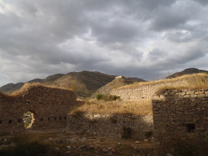
It’s the travel writer in me, but I can’t work on a book like Black Crown without wanting to map everything. As I’ve written elsewhere, understanding the Haitian Revolution and its aftermath becomes so much easier when you can place yourself in the middle of the action: being able to stand in the fort at Crête-à-Piérrot makes you instantly understand why Toussaint Louverture and Jean-Jacques Dessalines chose it as the perfect location to try to bleed the French army dry.
I’m just starting to write about the civil war between Henry Christophe and Alexandre Pétion that divided Haiti in two from 1807 until Christophe’s death, so of course I’ve been making maps so that I can understand how the fighting unfolded, especially in the earliest and most fluid years of the conflict. Turning to volume 3 of Thomas Madiou’s Histoire d’Haiti – still the best chronicle of this period – my eyebrows were raised at descriptions of fighting around Port de Paix, where much of the action revolved around the control of Fort des Trois Pavillons. This was one of the forts whose construction was ordered by Dessalines in 1804 as part of the move to fortify the country against a future French invasion, yet it ended up being used in part of an internal conflict.
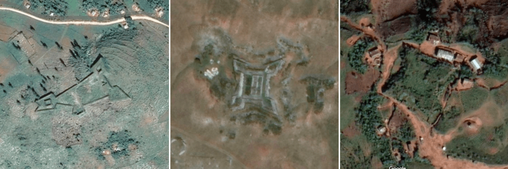
Trying locate Fort Trois Pavillons has proved a frustrating experience: there are two potential sites (one known locally, another from a 1963 survey map produced by the US army), and even poring over the best resolution Google satellite views I’ve so far been unable to definitively place it, leaving me to conclude that the fort may simply no longer exist. But it led me to try to track down the sites of all the forts built in 1804.
According to ISPAN, 27 forts were built under Dessalines’ orders. Here’s the list, with their rough location and the name of the commanding general who oversaw construction:
General François Capois:
- Fort Trois Pavillons (Port de-Paix)
General Henry Christophe:
- Fort Rivière (Grande Rivière du Nord)
- Fort Neuf (Grande Rivière du Nord)
- Fort Dahomey (Camp Coq)
- Fort Bayonnais (Ennery)
- Fort Sans Quartier (Marmelade)
- Fort Brave (Marmelade)
- Fort Jalouisière (Marmelade)
- Fort La Ferrière/Citadelle Henry (Milot)
- Fort Béké (Saint-Marc)
Governor-General Jean-Jacques Dessalines:
- Fort Culbuté (Marchand Dessalines)
- Fort Décidé (Marchand Dessalines)
- Fort Innocent (Marchand Dessalines)
- Fort Madame (Marchand Dessalines)
- Fort Fin du Monde (Marchand Dessalines)
- Fort Doko (Marchand Dessalines)
General Alexandre Pétion:
- Fort Jacques (Fermathe)
- Fort Alexandre (Fermathe)
General Yayou:
- Fort Campan (Léogâne)
General Laurent Ferou:
- Fort Marfranc (Jérémie)
General Jean-Louis François:
- Fort Bonnet Caré (Saint Louis du Sud)
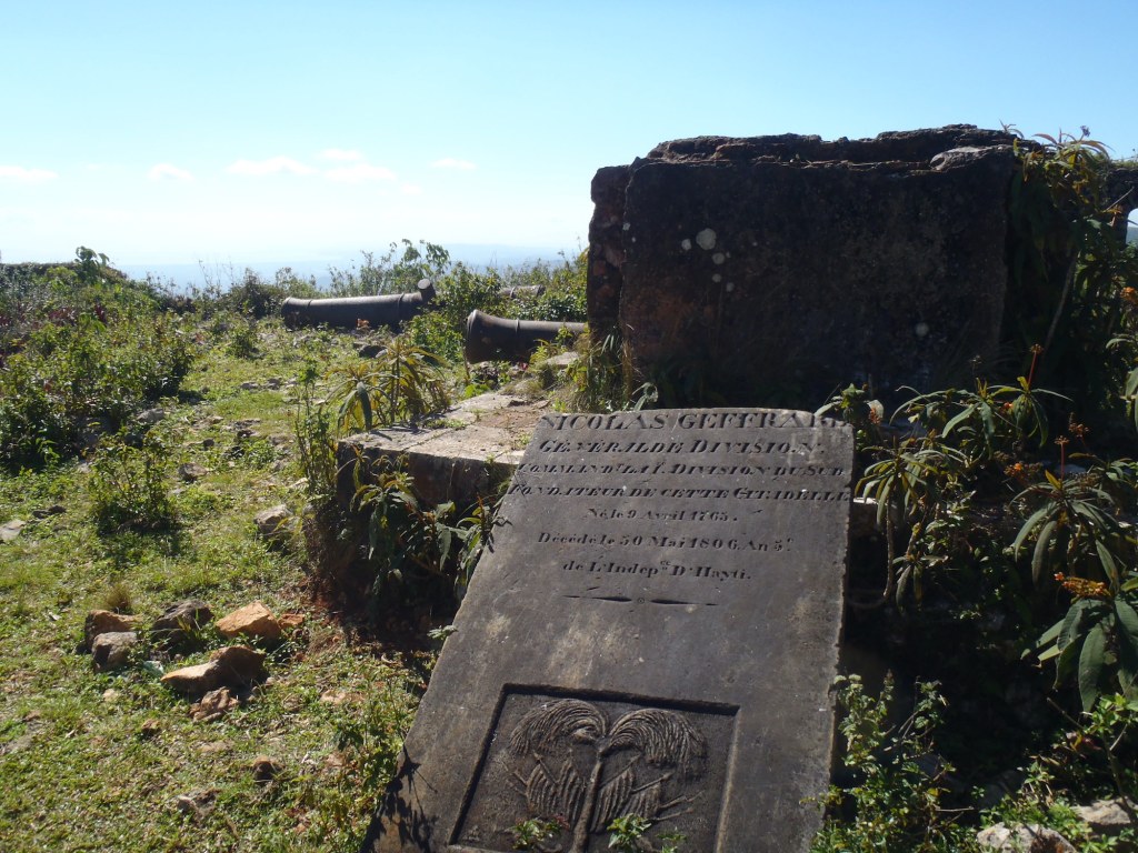
General Nicholas Geffrard:
- Fortress des Platons (Cayes)
General Magloire Ambroise:
- Fort Ogé (Jacmel)
Currently unknown:
- Fort Desbois (Anse-à-Veau)
- Fort Garit/Garic (Petit-Goâve)
- Fort Drouet (Arcahaie)
- Fort Delpèche (Arcahaie)
Of these forts, I’ve been lucky enough to visit almost half of these during my research trips for the Bradt Guide to Haiti, so they were easy to map. The others took much cross-referencing of sources, educated guesswork and lots of slowly scrolling through the satellite images on Google Maps.
To date, I’ve been able to pinpoint 21 of the 28 forts. Most of these are definitively placed; a handful remain tentative and still require ground-truthing or input from others.
Here’s the map so far. The 1804 fort are marked in purple. For added context I’ve added yellow pins for the forts and other buildings built by Henry Christophe after 1807, while those in red are colonial-era forts: mostly French but with a handful built during the British occupation.
Several of the 1804 forts have remained stubbornly hidden: Fort Neuf (Grand Rivière de Nord), Forts Sans Quartier, Brave and Jalouisière (all around Marmelade), Fort Béké (Saint-Marc) Fort Desbois (Anse-à-Veau) and Fort Garit/Garic (Petit-Goâve). Being unable to place Fort Jalouisière is particularly frustrating as it is pictured on the Haitian 50 gourde note. More French forts also remain to be added.
One interesting observation from satellite views of the different forts is the different degree of construction on some of them, making me wonder if some of them we ordered but never completed. From his letters of 1805-06, we know that Christophe spent much of his time around Milot directly overseeing the construction of the Citadelle, but the forts around Marmelade and Grand Rivière du Nord come up much less in his correspondence. Another letter alludes to Henri Barré, the head of the army engineers being sent to work at Marchand Dessalines. The forts here are particularly fine, and I suspect that Barré also oversaw the construction of the forts at Drouet and Delpeche, possibly under the orders of General Louis Gabart who was made commander of this division of the West province in 1805.
This map is very much a work in progress, so I welcome any input and comments!

